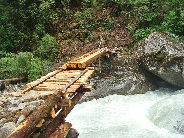
Monday, February 25, 2019
When the GOD showed up
29 July 2017, Dhalung rangeland, upper Mustang, Nepal
‘The gazelles must be resting now. I am going up again to get some more shots of them’, I told Prajwol and grabbed my camera, binoculars, GPS and compass.
‘I am too tired to climb again. And, it’s already 17:30’, he showed no interest of joining, leaving me to ascend alone.
We had spent half the day looking for Tibetan gazelles in the Plateau above our camp. I wanted to obtain close-up photographs of the beautiful small antelope because good photographs of the species from Nepal are almost non-existent. We encountered eight of them in three different occasions-once a lonely adult female, then two adult females and finally a small herd of five containing two adult females and three juveniles. However, very sharp eye sight and tremendous speed, their typical anti-predator instincts, prevented us from approaching them up close. When I was noting GPS location of the herd, Prajwol shouted that a juvenile ran next to me. I fired multiple shots with my camera on burst mode. That resulted a few good shots but the photographer in me still craved for better ones.
I met with a woolly hare on the way. Good shots of the species had already made into my camera; there was no point in wasting time. When the GPS indicated that I was very close to where the herd was during the day, a juvenile gazelle jumped in front and vanished from my sight in a blink of an eye. That very moment, a little up in the landscape, my eyes caught sight of an animal walking elegantly on a small ridge. I assumed it as a juvenile gazelle. A careful look suggested it to be otherwise. I clicked as many shots as I could before it disappeared behind the ridge. Oh my! An adult Eurasian lynx?
I hurried my steps towards the ridge to capture more photographs of the handsome cat. It reappeared on another ridge after a few minutes allowing me to take a few more shots. By the time I reached the ridge on which it was seen the first time, it had completely disappeared. The photographs in my camera were the only proofs that I was not dreaming.
Realizing that just a few minutes earlier, I was one on one with one of the least known wild felids of Nepal, I jumped as high as I could, punched my fists several times in air and shouted like a mad man. At 5023 masl, I was under the cloud of a very strange feeling.
The other day we had visitors from Choser village in our camp. They had shared the following incident:
‘Two villagers from Samdzong had killed a lynx near a monastery about 8-10 years ago. Two years later, both of them died, without any particular reason. We think the lynx was a God!’
Back at camp, I asked Ramu dai, our expedition cook, to fry some yak dry meat and also requested Lakpa baje, our mule keeper and local field guide, to pour in a cup of Chyang each for everyone.
‘What is the occasion?’ asked Prajwol.
‘I saw something special.’
‘A snow leopard?’ (Prajwol is familiar with my obsession towards the snow leopard).
‘Bigger than that. I saw the God!’
Prajwol checked the photo and contemplated, ‘Why did you not insist me to join?’
A few weeks later, back in Kathmandu, it got revealed that no one had ever photographed a lynx in its natural habitat in Nepal with a hand-held camera. The photograph I took that day became the first of its kind for Nepal.
Monday, September 4, 2017
BOOK REVIEW of HUMLA-Journey into the Hidden Shangri-La
FACTS THROUGH PHOTOGRAPHS
(English translation of the review by Kamal Maden)
http://nepalihimal.com/article/14680
Book-HUMLA: Journey into the Hidden Shangri-La
(People-Culture-Landscape-Wildlife)
Text/photographs: Naresh Kusi and Geraldine Werhahn
Publisher: Himalayan Map House
Pages: 128
Price: USD 28.99 (outside Nepal) and NPR 2000 (Nepal)

(English translation of the review by Kamal Maden)
http://nepalihimal.com/article/14680
Book-HUMLA: Journey into the Hidden Shangri-La
(People-Culture-Landscape-Wildlife)
Text/photographs: Naresh Kusi and Geraldine Werhahn
Publisher: Himalayan Map House
Pages: 128
Price: USD 28.99 (outside Nepal) and NPR 2000 (Nepal)

After a 55 minutes flight from Nepalgunj, the black-topped airfield of Simkot welcomes you to Humla. The district headquarter is where the foot trail to Limi valley starts. Walk north-west to reach Dharapori on the first day. You will make it to Okharthala/Kermi on the second day. Walk two more days towards the north and the wide valley of Talung opens up. Limi valley, one of the remotest places in Nepal, comes into scene from Talung. After another day of walk to the north, the trail turns west. You need to walk two more days to cover the three villages of Limi, the boundary of which is extended upto Namka la (pass).
Limi is considered the 'Shangri-La' of Humla, a remote district in the Karnali zone of mid-western development region. The valley is situated between 3700-4100 masl. A thin population of 904 people live in 181 households of Limi (National population census 2011), the culture of which is dictated by a strict monastic system. The arid Transhimalayan high altitude valleys of Limi are inhospitable for humans. These valleys are the grazing grounds of a fascinating assemblage of rare ungulates like wild yak, Tibetan wild ass/kiang, argali, Tibetan gazelle and their predators like snow leopard, Himalayan wolf, brown bear, Tibetan fox and red fox.
Opened to foreigners only in 2002 by the Government of Nepal, the sacred land of Limi still sees only a few tourists. This settlement is considered very ideal to study the traditional culture of Tibetan Buddhism, where it is preserved better than in other similar Himalayan valleys of Nepal.
The valley is also known to be important in terms of a unique biodiversity it houses. The pictorial book 'HUMLA: Journey into the Hidden Shangri-La' by wildlife biologists Naresh Kusi and Geraldine Werhahn is a proof to this.
A 2015 article in the journal Mammalia, published from France, mentioned the finding of wild yak to the north of Limi valley. This species was considered to have gone extinct in Nepal. Kusi and Werhahn, who are among the six authors of the article, made research expeditions to Limi in 2014-15 where the duo studied people, culture, landscape and wildlife.
Mammals
Big herds of Tibetan wild ass roam to the north of Limi valley. Known by the name Kiang in the Tibetan language (the same name is used in Nepali and English languages), its scientific name is Equus kiang. The animal, found only in the Transhimalayan valleys of higher Himalayas, is bigger than donkeys, its domestic relative. Its body is light brown and has white from legs up to the nose. The book presents beautiful photographs of kiangs grazing near Gyau khola (river) and running majestically in the steppes.
'The status of Nepal's mammals: The national red list series' published by the Department of National Parks and Wildlife Conservation (DNPWC) mentions that kiangs are found only within Mustang district with an estimated national population less than 100 individuals. But the authors claim to have counted about 600 kiangs in Limi.
The book also sheds light on a new fact about Tibetan gazelle in Nepal. The Gazella picticaudata (Procapra picticaudata at present), described by the British resident Brain Hodgson in 1846, was also said to be found only in Mustang. But the animal, which is 60 cm at shoulder and has a body length of 120 cm was also found in Humla as well.
Argali or Nayan is the biggest wild sheep. Available literature tells its presence only in Mustang district within the Annapurna Conservation Area. But the animal was also found in Chyakpalung area of Humla. The book lists 32 mammals in Humla of which 19 were observed while others were documented on the basis of signs like scats, fur, spines (Porcupine). This book has become the first book to publish the photo of wild yak in Nepal, a species that was considered extinct in the country.
Birds
The authors list 132 species of birds in Humla including Limi valley. Interestingly, there is a photo of Tibetan Lark, a species that was not recorded for Nepal before. The bird found earlier between 3200-4600 masl in China, India and Pakistan was found between 4800-4950 masl in Limi. The authors saw not just a single individual but a flock of about 30 birds.
In 1844, Hodgson had mentioned the presence of Common Redshank, a wetland bird, in Nepal. This bird, common throughout the world, had not been seem breeding in Nepal. Kusi and Werhahn managed to capture breeding pairs and a chick in Tso (lake) Lamgyok at 5010 masl.
A total of 74 species of birds, recorded less than 10 times in Nepal, are listed as vagrant. Ornithologists say that Black-necked Crane should be considered a vagrant for Nepal. But according to the people of Limi, the bird is seen in Ngin valley for more than six months of a year. Kusi also informed of seeing them for four months. Similarly the book also mentions the observations of Ashy Drongo, Intermediate Egret, Eurasian Cuckoo, Brown Fish Owl, Common Tern and Lesser Sand Plover in elevations higher than currently known.
Flora
British residents Oleg V. Polunin, William R. Sykes and L.H.J. Williams had been to Humla, Jumla and Dolpa in 1952 to collect herbarium specimens. According to senior botanist Keshab Rajbhandari, about 17,000 herbarium specimens were collected during that expedition. The collections are preserved in the British museum of London. Of these, Meconopsis simikotensis was collected from the bank of Dozam khola to the east of Simkot at 4270 masl while another species Ranunculus longicaulis was found near Simkot.
Kusi and Werhahn did not collect herbarium specimens but documented the flora in photographs. They sent the photographs to Bhaskar Adhikari, Mark Watson and Colin Pendry, the botanists at Royal Botanic Garden of Edinburgh. Photographs of more than three dozen such high altitude flowers have been put in the book. But the scientific names of about a dozen are incomplete. For example, a flower of Cremanthodium sp. has been shown. But there are more than 14 species in the genus Cremanthodium in Nepal.
Limels (people of Limi) speak the western dialect of Tibetan language. The book has also made attempts to throw light on various aspects of Limi in 83 photographs (besides the flora and fauna).
To sum up, the book is an important document presenting the diversity of Limi valley, which is largely unknown to rest of the world. The authors have planned to spend their royalty for wildlife conservation in Limi valley, which is a commendable initiative in itself.
Wednesday, March 30, 2016
THE NARROW ESCAPE FROM A HIMALAYAN BLACK BEAR
MAY 2012
Having a profound interest in wildlife conservation, we had a kind of excitement that was triggering our thoughts of encounters with wildlife as we had been continuously making way into the dense forests of Bhojpur. A few days earlier, we were informed by our mentors in Kathmandu that the friends in Khotang had seen a Himalayan black bear. We were filled with envy for them and wished
that we would be as lucky as them.
| My team |
The previous day, we had lost our way into the jungle as the pre existing trail inside the forest disappeared mid-way. We had returned back to a nearby village leaving our work on the plot for the next day. Starting off again the next day, we managed to get to the point by taking an alternate route. We were about to complete the field work when suddenly a strange sound caught our ears. For a minute or two, we could not make sure what it actually was. But as the sound grew louder and seemed to be coming right towards us, we confirmed that it was a Himalayan black bear. We were excited at the beginning, but when we realized that the bear was coming downhill towards us, our excitement turned to fear. While we hastily gathered the field equipment, we noticed the tree leaves moving some 20 meters uphill. This clearly meant time had wanted us to take immediate decisions. In no time, we ran away as fast as we could. I was in half pants, got scratched by thorns and developed wounds on my thigh that remained till the end of the journey. We kept running till we reached a nearby village. It was undoubtedly a dangerous moment.
When we shared the incident to other teams, it was revealed that our friends in Khotang had not actually seen any black bear as was reported earlier. They had been simply warned by the villagers to remain alert in the forests. In our case, it was a different and noticeably an adventurous moment.
Sunday, February 28, 2016
BEWARE OF ALTITUDE. IT KILLS!
I have been travelling
to high altitudes of Nepal for eight years now. I have come through two incidents
in connection with altitude sickness till date. The first happened in October
2010 at Lobuche (4900 m asl), Sagarmatha National Park. Two of my friends had suffered it but the magnitude
was mild. Since the incident took place in a hotel, it got an easy settlement!!
The second one took
place in Dec 2013 at Thini, Mustang, Annapurna Conservation Area. It happened inside a jungle, nearly 4-5
hours far from any human settlements, with just two of us to rescue the victim.
The magnitude was larger. Being the first of its kind in terms of severity, it
urged me to share the happening with all my friends concerned with high
altitude.
The
narrative:
Early in the morning we
left Thini village (2855 m asl) and ascended towards Ghasung forest in search
of musk deer signs.
| Thini village |
I was accompanying a friend of mine for his M.Sc. thesis field
work on musk deer. We had hired Mr. Bal Bahadur Thakali (55) as local field guide.
We had a distant view of the Dhaulagiri range and ascended up.
| Dhaulagiri range, a distant view |
My friend was coming up
very slow as it was the first time he had come to this elevation. At 3700 m
asl, he complained of mild headache. I suggested him to drink as much water as
he could. We halted for lunch at 11:30. At 12:15, we hit upon a resting site of
musk deer. Soon the search progressed interestingly, musk deer pellets were
observed at many places.
| Taking the field data of musk deer pellet |
We spent almost two hours at the elevation of 3800 m
asl.
At 14:00, we started to
descend. After a while, we reached near Chemaso lake.
![]() |
| Chemaso lake |
Right then, my friend
suffered a severe headache. As he sat down to rest, he complained of difficulty
in breathing. I offered him some water. We tried to put him in comfort by
telling that everything will be okay once we descend further. When we were
about 300 m far from the lake, he gave up the effort of descent and lied down on
the ground. I checked for water but the bottle had gone empty. So, I rushed
towards the lake to fetch water, keeping him under the care of our field guide.
When I hastily reached
near him with water in the bottle, he was lying down with his whole body
stretched to the ground. I could not see our field guide nearby. My heart
skipped a beat upon seeing this. I scanned the surrounding; the field guide was
leaning back on a stone about 5m away. I sighed with a little relief.
As I approached him, he
was almost unconscious. We made him drink water, that too with difficulty. We fed
him some energy biscuits and some pieces of garlic. He would blink his eyes
with difficulty and mostly preferred to keep them closed. I almost ordered him
to keep them open. I took off his bag and carried them on the top of my own
bag. We suggested him to rise up slowly, but he could not do that on his own.
So, each of us took hold of a hand of his and almost dragged him down. After a
while, he managed to walk a little, but still needed our support!
Upon descending about 400
m, he showed signs of improvement. We made him eat 2-3 chapatis and offered more
water. He was well off now but the headache was still on. By the time we reached
the hotel, I ordered a bowl of garlic soup for him. Drinking it gave him more
comfort. After the dinner, he was back to himself again.
My
Say:
Altitude sickness may
envelope anyone. There is no any hint as to segregate who will suffer from it
and who will be immune to it. During my research trip to Sagarmatha
National Park, I was told by a trekking guide that a French traveler who did
not suffer altitude sickness for ten Everest Base Camp (EBC) expeditions
suffered it during the 11th and passed away. Altitude sickness turns
a killer when we neglect it.
Based on the scholarly
consultations and individual experience, I list some important points to
consider (Additions will be highly appreciated):
· 1. As soon as you realize symptoms like
headache, dizziness, nausea, difficulty in breathing or imbalance in walking, descend
down at least 300m. DO NOT HIDE YOUR PROBLEM. Make sure that you do not descend
alone.
· 2. Maintain a slow and consistent rhythm of
ascent. Going up with additional speed at easy terrains and resting longer
afterwards may also trigger it.
· 3. Drink enough fluids. These will maintain the supply of additional
oxygen. But, do not ever drink alcoholic beverages in the name of having
fluids. These will make blood circulation faster and thus increase the demand
for oxygen hence leading to depletion in oxygen level.
· 4. Do not ascend with empty stomach. Carry
chocolates and other easy carbohydrate sources. Keep eating from time to time.
· 5. Garlic, turmeric and Zanthoxylum (timur)
are good natural medicines.
· 6. Always carry a first aid kit.
The final line:
Never underestimate altitude, the
fascinating high altitude landscapes would turn into a killer if you do not
comply with the natural rules they have set!
Monday, January 25, 2016
THE BLACK GIANT OF THE HIMALAYAS
In 2014 while visiting the remote trans-Himalayas of upper Humla for research,
our team came across with wild yaks that were considered extinct in Nepal.
Following the rediscovery I led a research project on wild yaks in the same
area in 2015.
Unlike domestic yaks wild yaks have a larger
body size, bigger horns, grayish muzzle, a conspicuous hump, and a consistent
black coat. These robust animals run away as soon as they spot humans, and
therefore are referred as 'ferocious cowards'. According to International Union
for Conservation of Nature and Natural Resources, their population has declined
by about 30 percent in the last 30 years primarily due to human hunting.
Wild yak Bos mutus in Gyau Valley, upper Humla
|
People and wild yaks
Our local guide told us that wild yaks are
called Dong in Tibetan language and that various parts of the
animal have medicinal value. For example dried wild yak blood from
the heart is used for low altitude sickness and burnt hair from
its forehead is used for mouth sores.
It is evident that humans tamed wild yaks to
create domestic yaks used as valuable beasts of burden in the Himalayan
regions. Limels, people from Limi VDC, have an intricate cultural
relation with wild yaks. They use wild yak tendons to make the rope of a bow
that is used in wedding ceremonies. The groom hits an arrow from the bow
into a wooden plate placed around the waist of the bride symbolizing a formal
union between the two. Similarly if a drought persists for a long time they
worship water sources with wild yak hair deposited close by. They believe that
such a practice recharges the water sources.
The local herders complained about their
occasional conflicts with wild yaks. They believe that wild yaks from Tibet
usually travel across the border into Humla during the months of July to August
to mate with female domestic yaks. Villagers confessed to trying to kill the
wild yaks as the hybrids resulting from interbreeding between wild yaks
and domestic yaks can be shyer and difficult to domesticate. But the greed of
obtaining large amount of meat also drives them to kill wild yaks, which they
failed to mention.
The Limels and the Rongbas (people
from lower elevations) kill wild yaks for meat. During the last ten years at
least eight wild yaks were killed in Humla. A young herder from Chuwa khola valley,
east of Limi valley, boasted that he, along with 18 of his friends, had killed
three wild yaks on a single day in 2013. They kept the meat and sold the
head in Tibet since Tibetan people hang the head above the entrance of
their homes as a status symbol. This has also motivated regular
killings of wild yaks.
Need for Conservation
We saw two wild yaks in Gyau Valley in June
2014 while in July 2015 we saw only one. The herders had not reached these
meadows for grazing their livestock back in 2014 but in 2015 some domestic yaks
were already grazing in the same location. Ironically we saw around 200
domestic yaks grazing in the same place when we returned after 20 days having
explored other valleys. This clearly indicates that herders encroach upon the
natural habitat of wild yaks during the summer months. This proximity increases
the likelihood of hybridization between the domestic and wild yaks which can
lead to the extinction of the wild species. Domestic yaks may also contract
diseases such as Brucellosis and Salmonella to wild yaks when the two occupy
the same range.
Herders with their domestic yaks
|
The places where we sighted wild yaks were
relatively close to the Chinese border and the animals fled northward after
spotting us. Renowned wildlife biologist, George Schaller, mentions that wild
yaks are not migratory but may shift ranges seasonally or if harassed. However
it is not confirmed if the wild yaks we encountered are residential in Nepal,
possibly shifting range to a far-off location due to habitat encroachment by herders
as suggested by Schaller, or if they are migrants from Tibet as believed by the
herders.
Wild yak habitats in Tibet have degraded due
to an increasing road network. In upper Humla though, this factor is not
significant yet as remote locations preferred by wild yaks
are unlikely to be subjected to road encroachment in the near
future.
Limels assume that about five to ten wild yaks inhabit their
area. About the same number of them is considered to roam the pastures of Chuwa
khola valley. The herders reported sightings of four wild yaks in July 2015 and
three in August 2015 in the valley.
Wild yaks face diverse threats such as hunting
for meat, poaching for heads, habitat encroachment by domestic livestock and
conflict with herders. As such, it is likely that such a small remaining
population of the rare wild yaks in Humla will be lost if appropriate
conservation initiatives are not taken immediately. It's high time all
major stakeholders of wildlife conservation in Nepal came together and act effectively
for wild yak conservation; otherwise these black giants of the
Himalayas will probably go extinct from Nepal in a few years.
http://bit.ly/1OU4e3f
Thursday, December 31, 2015
TSO-ROLPA: A DRAMATIC JOURNEY
During
the secondary level of our school days, there was an article on Tso-rolpa (Tso means lake in Tibetan language). All I recall of that article is
the mention of the fact that the lake is located somewhere in the Himalayan
region and that it is prone to outburst.
Years
passed but the traveler inside me kept reminding me of the lake. Meanwhile I had
joined a BSc in Environmental Science at Khwopa College, Bhaktapur. The
coordinator of Environmental Science faculty in the college was a geologist.
During his first lecture, he talked of Tso-rolpa. In the lectures that
followed, he mentioned his involvement in a geological survey of the lake. Thereafter,
there was rarely a lecture where he did not mention the lake.
I
do not know what triggered so much of his geological interest in the lake. But
his regular mention of the lake fueled my plan to explore this lake myself. The
time came in the monsoon of 2009, when I set off on a journey to Tso-rolpa.
We
follow the heart
On
the final day of the first terminal exam, I made a plan to visit Tso-rolpa and asked
my friend Krishna Dev Hengaju if he would like to join.
He replied without even thinking twice, 'Sure,
let's go'.
Having
made a decision, we paid a visit to the coordinator, to get his advice on which
geologic aspects we could study in the region.
He
replied: 'Monsoon is about to begin and you are planning of going to Tso-rolpa?
I do not recommend!'
Young
at heart, we were determined to make our plan a reality. So our ears remained
deaf to his response and the next morning we caught a local bus to Singati.
The
bus ran east through the black-topped Araniko highway to reach Charikot which
is the headquarter of Dolakha district. Beyond Charikot, the bus drove through
a dirt road and dropped us at Singati, a local market situated by the
confluence of Bhotekoshi and Tamakoshi Rivers.
It
started to rain while we were having snacks at Singati. We put on our raincoats
and started to walk. On the way we frequently encountered mule caravans, and had
sightings of a Squirrel Funambulus sp. and a flock of Kalij Pheasants Lophura
leucomelanos. These early sightings had pleasant impressions on us.
Darkness had fallen by the time we reached Jamune and we spent the night there.
![]() |
| Jamune |
A night in the middle of a forest
The
Upper Tamakoshi Hydroelectric Project (UTHP) had just begun its activities in
the area. An access road was being built to its powerhouse and the local people
were actively involved in the construction works. We passed many villagers
drilling stones from the side hills; some were even breaking them manually with
iron hammers.
![]() |
| Local people involved in construction works |
Seen in equal numbers were the local people carrying fuel in a doko
(a basket woven from bamboo), to be supplied for a tunnel construction being
carried at Gongar. While having lunch in a local shop we heard the rocks being
blasted for the opening of the tunnel.
| The tunnel site at Gongar |
We
crossed a suspension bridge over the Tamakoshi River and ascended towards
Simigaun (2000 m asl). It was a tiring 90 minutes ascent to reach the village.
When we reached Gumbadanda, the clock had already ticked 4:50 PM but the sky
was still very bright. We asked with the villagers about the nearest settlement
that we would find from Gumbadanda.
'There
is a single house at Surmuche, which can be reached after about 90 minutes walk.
But you need to take a right turn from the main trail in the middle of the
forest to reach it', told a villager. So we continued.
The
trail passed through a dense forest. After about one and a half hours, we lost
our way. Broken twigs of trees were put on the trail to indicate that there is
no way ahead. We removed the obstructions and made useless attempts to locate
the trail. Realizing that we were stranded we thought of returning to
Gumbadanda, but it was already too late. After a short while, we rejoined the
main trail and gave up the thought of returning. At 7:45 PM we found ourselves
near an abandoned tea house in the middle of the forest. We were relieved. Complete
darkness ruled the scene and we were left with only one option that was to spend
the night in that abandoned tea house!
The
tea house had a big iron lock on its door. We tried to break the lock with
stones, but did not succeed. After about a few minutes of desperate attempts of
breaking the lock, we realized that the side walls of the house were loosely
sealed with wooden rods. Like thieves, we took out some of the logs from the
top row and entered inside.
As
we managed to get inside, we lit our torchlight. Our legs were bleeding as
leeches had sucked enough of our blood.
In
the meantime, we felt thirsty and checked our water bottles. They were empty.
We had carried some dry foods. Eating dry foods meant getting thirstier. We
also had some polo chocolates. An idea came to my mind, 'Let's put this
chocolate in mouth and leave it without chewing for some minutes. It will
produce a fair amount of saliva and we shall not be as thirsty!' The idea
worked.
We
began to feel cold as we were in shorts and thin jackets. We found some wooden
logs and dry ferns stored at a corner of the house and in no time we had lit a
warming fire.
There
were some wooden planks put as seat for the customers. We tried to make a
temporary bed with them. But they did not rest perfectly horizontal on the
floor.
Soon
it began to rain. To our despair, the metal roof of the house had rusted at
many places. Raindrops fell on our body through the holes on the roof. We
couldn’t sleep and stood up again. Chilled by the rain we lit the fire again.
The Rolwaling River was flowing down far away. Its thundering sound combined
with the raindrops hitting on the metal roof gave the impression that the rain was
growing heavier. Trembling and holding each other to stay warm, it took a long
time until total exhaustion let us fall asleep.
The
next morning we started the day early. We left the house feeling sorry to have
burnt so much of the firewood and the dry ferns, and felt fearful of getting caught.
| Coming out of the tea house |
But
we were feeling very thirsty. This forced us to start moving in the hope of finding
potable water ahead. We could hear the Rolwaling River rushing down but it was
too far. The thirst grew so intense that we collected the dew drops on plant
leaves and the water drops seeping down from the rock crevices. After another
hour we found a small pit with water. We collected the water and drank it without
caring if it is worth drinking or not.
| Collecting water from a pit by the trail |
Strangers
in Beding village
After
a walk of about four hours we found a small hut at Kelchey where we properly
quenched our thirst.
![]() |
| At Kelchey |
From Dongang, we followed the Rolwaling River and headed
east. A short while later we had to cross the River to move towards Beding
village. But the existing suspension bridge was completely destroyed by a
recent landslide.
![]() |
| The destroyed suspension bridge |
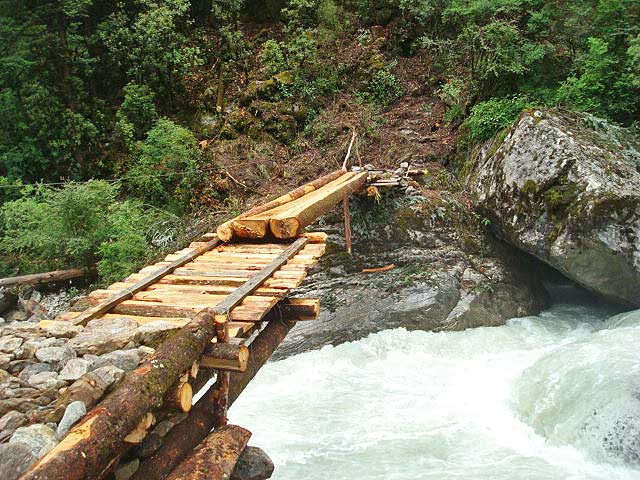
Luckily, the local people had put a new wooden bridge over
the River just the day before.
| The wooden bridge |
As
the day progressed the fog kept getting thicker and reducing the visibility.
We
reached Beding (3700 m asl) at dusk. Located by the side of Rolwaling River, the
Sherpa village had a charming outlook.
![]() |
| Beding village |
With no warm clothes we were shaking. There
was only one lodge in the village. The price was much higher than we had
expected. So we opted for an accommodation in a local house and inquired a few
villagers. To our surprise, nobody seemed to be interested in accommodating us.
Everyone said, 'We have no room. Ask in the next house.'
We
later learned that a group of young boys had come to visit Tso-rolpa a few
weeks before. They had stolen some equipment from the office of Tso Rolpa GLOF
Risk Reduction Project (TRGRRP) situated by the lake. The group had also stolen
an idol from the monastery of Beding. These events had made the villagers
suspicious of any outsiders.
A
young girl that I had asked if she had a room for us to stay replied with a
sharp scolding.
It
was revealed later that the girl and her sister were living in that house alone.
Seeing us moving around the village a drunkard had told the two sisters, 'There
are two young boys from the city. Tonight, you either sleep with them or sleep
with me!'
Without
asking anyone further we returned to the lodge. But now the owner was not in the
mood anymore to give us a room. His wife took pity and managed a room for us.
By the Tso-rolpa
We
reached Na gaon (4180 m asl) after a two hours walk from Beding.
![]() |
| Na gaon |
Another
two hours of walk and we were by the Tso-rolpa. Situated at an elevation of
4580 m asl the average length of the lake is 3.20 km at a width of 0.5 km and
depth of 138 m.
| Tso-rolpa |
Considering
the risk of a Glacial Lake Outburst Flood (GLOF) event, TRGRRP was already in
place since nine years. Implemented by the Government of Nepal with the
economic support from Netherlands Development Agency (NEDA), the project had
channelized water from the lake through an outlet. Three staffs were appointed
to periodically open and close the gate of the outlet to check the rise in
water level of the lake. The out flowing water had been used to run a small
hydro power plant, the electricity from which was used to lit the office and to
operate the equipment.
We
spent two hours by the lake. As it got colder fast, we descended down to Na gaon.
For
the dinner we had dhindo of millet (recipe: millet flour is put in hot water,
stirred till it solidifies and served). We had ordered it ourselves but had difficulty
eating it since we were not used to such a dish. However, the fresh milk of yak
was too tasty.
The vanished trails
The
next morning we took leave of Na gaon and descended fast. At some places
the trails we had come through had completely disappeared as the villagers had
cut the entire hills to open the track for the UTHP.
The
TRGRRP had put one siren at each village from Na gaon upto Simigaon to
notify the villagers if a GLOF event occurred. But the sirens were not
functional anymore as most of the important components such as batteries and
solar cells were stolen.
![]() |
| A siren put to inform of the GLOF event |
The
monsoon had progressed after we moved up and it rained almost every day. Near
Bhorley, the usual trail was blocked due to a landslide. The villagers were
busy making an alternate trail through the nearby forest.
| Villagers opening an alternate trail near Bhorley |
Subscribe to:
Posts (Atom)