Thursday, December 31, 2015

TSO-ROLPA: A DRAMATIC JOURNEY

During the secondary level of our school days, there was an article on Tso-rolpa (Tso means lake in Tibetan language). All I recall of that article is the mention of the fact that the lake is located somewhere in the Himalayan region and that it is prone to outburst.

Years passed but the traveler inside me kept reminding me of the lake. Meanwhile I had joined a BSc in Environmental Science at Khwopa College, Bhaktapur. The coordinator of Environmental Science faculty in the college was a geologist. During his first lecture, he talked of Tso-rolpa. In the lectures that followed, he mentioned his involvement in a geological survey of the lake. Thereafter, there was rarely a lecture where he did not mention the lake.

I do not know what triggered so much of his geological interest in the lake. But his regular mention of the lake fueled my plan to explore this lake myself. The time came in the monsoon of 2009, when I set off on a journey to Tso-rolpa.

We follow the heart

On the final day of the first terminal exam, I made a plan to visit Tso-rolpa and asked my friend Krishna Dev Hengaju if he would like to join.

 He replied without even thinking twice, 'Sure, let's go'.

Having made a decision, we paid a visit to the coordinator, to get his advice on which geologic aspects we could study in the region.

He replied: 'Monsoon is about to begin and you are planning of going to Tso-rolpa? I do not recommend!'

Young at heart, we were determined to make our plan a reality. So our ears remained deaf to his response and the next morning we caught a local bus to Singati.

The bus ran east through the black-topped Araniko highway to reach Charikot which is the headquarter of Dolakha district. Beyond Charikot, the bus drove through a dirt road and dropped us at Singati, a local market situated by the confluence of Bhotekoshi and Tamakoshi Rivers.

It started to rain while we were having snacks at Singati. We put on our raincoats and started to walk. On the way we frequently encountered mule caravans, and had sightings of a Squirrel Funambulus sp. and a flock of Kalij Pheasants Lophura leucomelanos. These early sightings had pleasant impressions on us. Darkness had fallen by the time we reached Jamune and we spent the night there.

Jamune
A night in the middle of a forest

The Upper Tamakoshi Hydroelectric Project (UTHP) had just begun its activities in the area. An access road was being built to its powerhouse and the local people were actively involved in the construction works. We passed many villagers drilling stones from the side hills; some were even breaking them manually with iron hammers. 

Local people involved in construction works
Seen in equal numbers were the local people carrying fuel in a doko (a basket woven from bamboo), to be supplied for a tunnel construction being carried at Gongar. While having lunch in a local shop we heard the rocks being blasted for the opening of the tunnel. 

The tunnel site at Gongar
We crossed a suspension bridge over the Tamakoshi River and ascended towards Simigaun (2000 m asl). It was a tiring 90 minutes ascent to reach the village. When we reached Gumbadanda, the clock had already ticked 4:50 PM but the sky was still very bright. We asked with the villagers about the nearest settlement that we would find from Gumbadanda.

'There is a single house at Surmuche, which can be reached after about 90 minutes walk. But you need to take a right turn from the main trail in the middle of the forest to reach it', told a villager. So we continued.

The trail passed through a dense forest. After about one and a half hours, we lost our way. Broken twigs of trees were put on the trail to indicate that there is no way ahead. We removed the obstructions and made useless attempts to locate the trail. Realizing that we were stranded we thought of returning to Gumbadanda, but it was already too late. After a short while, we rejoined the main trail and gave up the thought of returning. At 7:45 PM we found ourselves near an abandoned tea house in the middle of the forest. We were relieved. Complete darkness ruled the scene and we were left with only one option that was to spend the night in that abandoned tea house!

The tea house had a big iron lock on its door. We tried to break the lock with stones, but did not succeed. After about a few minutes of desperate attempts of breaking the lock, we realized that the side walls of the house were loosely sealed with wooden rods. Like thieves, we took out some of the logs from the top row and entered inside.

As we managed to get inside, we lit our torchlight. Our legs were bleeding as leeches had sucked enough of our blood.

In the meantime, we felt thirsty and checked our water bottles. They were empty. We had carried some dry foods. Eating dry foods meant getting thirstier. We also had some polo chocolates. An idea came to my mind, 'Let's put this chocolate in mouth and leave it without chewing for some minutes. It will produce a fair amount of saliva and we shall not be as thirsty!' The idea worked.

We began to feel cold as we were in shorts and thin jackets. We found some wooden logs and dry ferns stored at a corner of the house and in no time we had lit a warming fire.

There were some wooden planks put as seat for the customers. We tried to make a temporary bed with them. But they did not rest perfectly horizontal on the floor.

Soon it began to rain. To our despair, the metal roof of the house had rusted at many places. Raindrops fell on our body through the holes on the roof. We couldn’t sleep and stood up again. Chilled by the rain we lit the fire again. The Rolwaling River was flowing down far away. Its thundering sound combined with the raindrops hitting on the metal roof gave the impression that the rain was growing heavier. Trembling and holding each other to stay warm, it took a long time until total exhaustion let us fall asleep.

The next morning we started the day early. We left the house feeling sorry to have burnt so much of the firewood and the dry ferns, and felt fearful of getting caught.

Coming out of the tea house
But we were feeling very thirsty. This forced us to start moving in the hope of finding potable water ahead. We could hear the Rolwaling River rushing down but it was too far. The thirst grew so intense that we collected the dew drops on plant leaves and the water drops seeping down from the rock crevices. After another hour we found a small pit with water. We collected the water and drank it without caring if it is worth drinking or not.

Collecting water from a pit by the trail
Strangers in Beding village

After a walk of about four hours we found a small hut at Kelchey where we properly quenched our thirst.

At Kelchey
From Dongang, we followed the Rolwaling River and headed east. A short while later we had to cross the River to move towards Beding village. But the existing suspension bridge was completely destroyed by a recent landslide. 
The destroyed suspension bridge
Luckily, the local people had put a new wooden bridge over the River just the day before.
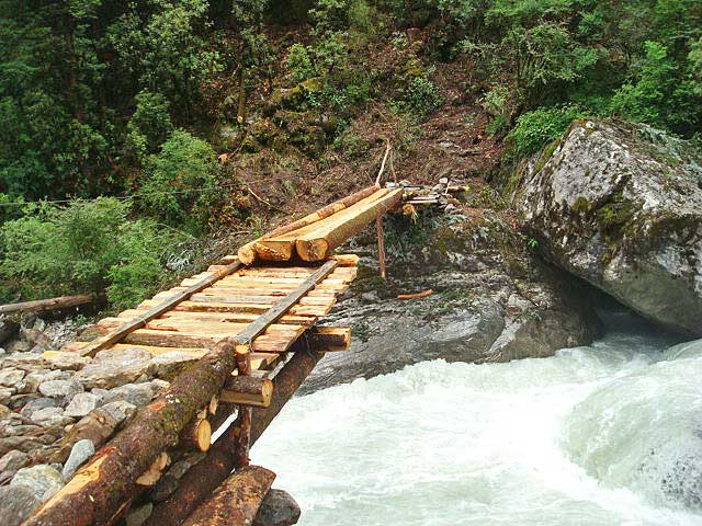
The wooden bridge
As the day progressed the fog kept getting thicker and reducing the visibility.

We reached Beding (3700 m asl) at dusk. Located by the side of Rolwaling River, the Sherpa village had a charming outlook. 
Beding village
With no warm clothes we were shaking. There was only one lodge in the village. The price was much higher than we had expected. So we opted for an accommodation in a local house and inquired a few villagers. To our surprise, nobody seemed to be interested in accommodating us. Everyone said, 'We have no room. Ask in the next house.'

We later learned that a group of young boys had come to visit Tso-rolpa a few weeks before. They had stolen some equipment from the office of Tso Rolpa GLOF Risk Reduction Project (TRGRRP) situated by the lake. The group had also stolen an idol from the monastery of Beding. These events had made the villagers suspicious of any outsiders.

A young girl that I had asked if she had a room for us to stay replied with a sharp scolding.

It was revealed later that the girl and her sister were living in that house alone. Seeing us moving around the village a drunkard had told the two sisters, 'There are two young boys from the city. Tonight, you either sleep with them or sleep with me!'

Without asking anyone further we returned to the lodge. But now the owner was not in the mood anymore to give us a room. His wife took pity and managed a room for us.

By the Tso-rolpa

We reached Na gaon (4180 m asl) after a two hours walk from Beding. 

Na gaon
Another two hours of walk and we were by the Tso-rolpa. Situated at an elevation of 4580 m asl the average length of the lake is 3.20 km at a width of 0.5 km and depth of 138 m.

Tso-rolpa
Considering the risk of a Glacial Lake Outburst Flood (GLOF) event, TRGRRP was already in place since nine years. Implemented by the Government of Nepal with the economic support from Netherlands Development Agency (NEDA), the project had channelized water from the lake through an outlet. Three staffs were appointed to periodically open and close the gate of the outlet to check the rise in water level of the lake. The out flowing water had been used to run a small hydro power plant, the electricity from which was used to lit the office and to operate the equipment.

We spent two hours by the lake. As it got colder fast, we descended down to Na gaon.

For the dinner we had dhindo of millet (recipe: millet flour is put in hot water, stirred till it solidifies and served). We had ordered it ourselves but had difficulty eating it since we were not used to such a dish. However, the fresh milk of yak was too tasty.

The vanished trails

The next morning we took leave of Na gaon and descended fast. At some places the trails we had come through had completely disappeared as the villagers had cut the entire hills to open the track for the UTHP.

The TRGRRP had put one siren at each village from Na gaon upto Simigaon to notify the villagers if a GLOF event occurred. But the sirens were not functional anymore as most of the important components such as batteries and solar cells were stolen.

A siren put to inform of the GLOF event
The monsoon had progressed after we moved up and it rained almost every day. Near Bhorley, the usual trail was blocked due to a landslide. The villagers were busy making an alternate trail through the nearby forest.

Villagers opening an alternate trail near  Bhorley

We caught a bus to Kathmandu at Singati. It slipped at various places in the muddy dirt road. We had to get out and push the bus a number of times until we reached Charikot safely. At Kharidhunga the bus stopped and could not start up again. We took another bus and came back to Kathmandu.

Sunday, October 18, 2015

KHAPTAD-A MEMOIR


The slogan 'Wonderful Far-west' appears on most of the buses that run to Dhangadi and Mahendranagar from Kathmandu. Whenever there is any discussion of the major attractions in Far-west, the wondrous picture of Khaptad immediately flashes. Khaptad is often presented as 'The Heaven on Earth' by its promoters. The area was declared a National Park in 2040 B.S., comprising 225 km2 of four hilly districts namely Doti, Bajhang, Bajura and Achham. But this heavenly landscape has seen few international tourists in 32 years. Keep aside the pilgrims who visit the area during the annual religious fairs of Ganga-Dashahara and Janai Purnima and it will reveal that the flow of domestic tourists is not significant either.

This way or that way, I keep going!

I was planned to go explore the lake Rara during Dasain vacation of 2011. One of my friends had shown an interest of joining me. He requested me to shift it after the festival and I agreed.

On the day set for departure, I packed all my gears early in the morning and called my supposed companion. He did not respond. I kept ringing his phone till 14:00 but he did not pick the phone. Around 14:30 a message came to my cell phone that read, 'Sorry friend, I am unable to join!'

The message annoyed me for a while. In no time, I dialed another friend, 'Would you like to go to Rara?'

'Rara will require more days. What about Khaptad?'

'Let's do that.'

The next day, three of us (Prajwal Byanju, Sanej Prasad Suwal and me) caught a bus to Dhangadi.
As usual, the bus played folk-duet songs (Lok-dohori), non-stop. At Dhangadi, we took another bus to Silgadi, Doti.

The bus took a break of about half an hour at Dipayal, headquarter of the far-western development region.

'Hey brothers, you seem to have returned from a foreign country. Where had you gone?' a passenger asked us.

'We came from Kathmandu, not from a foreign country. We are here to visit Khaptad' I replied.
This short conversation made us realize how uncommon the culture of travelling is in Nepal.

The bus rose from the shallow depression of Dipayal and dropped us on the hilly market of Silgadi at 21:00 in the night. Dabal Bahadur Singh, who was in the same bus with us, proposed that we spend the night at his house. We agreed instantly.

I was lying on the bed writing my diary when my phone rang.

 'Happy birthday brother!' came the sound of Ankit.

The Hazmola shot

We took leave of Dabal Bahadur dai early in the morning. 
Silgadi bazaar
For a short while we walked on the black-topped road leading to Shantinagar. But soon we diverted towards NTV tower, the trail being almost two hours earlier to reach Baglek than the black-topped one. 
Baglek
Near the NTV tower, the Nepal army had managed a big tank to provide drinking water facility to the travelers. A little ahead was put a route map of Khaptad National Park (KNP). We had a pleasant impression.

Around 15:00 we reached Jhigrana, from where the boundary of KNP started. 

Jhigrana
Here we met a group of fellow trekkers; Prawesh Paudel and Sambit Bhandari from Kathmandu and Sabin Pathak and Janak Bhatt from Kailali. Our team grew in size.

Beyond Jhigrana, the route went through a steep trail. Unfortunately there was no easy availability of drinking water in this section. KNP could have drawn water from streams into a tank through pipes, just like near the NTV tower!

On the way, we met another group of Nepalese coming back from Khaptad. They told us that they had an encounter with a wild boar (Sus scrofa) and advised us to stay alert as the route ahead passed through a dense forest. Instead of developing fear, my heart silently craved for an encounter with the wild boar. According to their advice, we moved forward making noise every time we saw a rootling of a wild boar and counting each other at intervals. We reached Bichpani after four hours.

At Bichpani, we stopped by the lodge run by KNP. 

Bichpani
Although the lodge had three staffs, two of them had gone home leaving behind an old man. We asked him what was available for dinner.

'Dal-bhat-tarkari' he replied with a smile.

As the old man was washing some potatoes, we asked him to put some of them in the fire as the fire-cooked potatoes always taste better.

Having taken dinner, Prajwal proposed that we celebrate my birthday. We gathered firewood, made a camp fire and sang songs to the top of our voices. In the meantime Prawesh came with a small bottle of locally-brewed alcohol. I told him that I do not drink alcohol. 

'Come on, it's your birthday. You cannot decline.' everyone shouted.

We finally made an agreement that I take just a few drops.

Prawesh gave each of us a Hazmola (a digestive tablet easily available in market) and said, 'Everyone should finish the alcohol in a single take and then eat the Hazmola. We call this the Hazmola shot!'

(Note: There is a popular Nepali television commercial advertisement of the Hazmola that concludes, 'Je aauncha mazzale pachauncha' i.e. 'Eat whatever, Hazmola will digest.')

The rolling pastures

I had difficulty sleeping the previous night because the zipper of my sleeping bag was broken. The lodge had only one room to accommodate us and that too had no door. Cold air kept hitting my body all night. I woke up very early (around 04:30), gathered some dry leaves and tried to make a fire. But I could not. Everyone got up by 6:15 and we asked the old man for tea. But there was no sugar left in the lodge. We had a glass of hot water each.

After walking for a few minutes, our eyes caught sight of the rolling pastures. These features stood behind the fame of KNP. All the exhaustion we had from yesterday was gone upon seeing the wonderful landscape. 
The rolling pastures of KNP
We were walking by the bank of Ghat khola, crossing the wooden bridges over the river at many places. Stepping on the wooden bridges gave us a strange pleasure. We could not prevent ourselves from taking a bath in the cold water. By the time we reached Tribeni, the natural beauty had held us captive. Tribeni, a confluence of three small rivers, is a holy place of the region, visited by a large number of pilgrims during Ganga-Dashahara and Janai Purnima every year.

Tribeni
A walk of five hours from Bichpani brought us to the headquarter of KNP. 

By the headquarter of KNP
Some horses and mules were grazing in the pastures and wild boar rootlings were numerous. In the evening, the environment grew wilder by the howling of golden jackals (Canis aureus) nearby. For some minutes, we were lost gazing at the stars in the vividly open sky.

Wild moments

The rootlings of wild boar injected in us a desire of observing the animal. For this, Prajwal, Sambit and me woke up at 04:00 the next morning and made our way into the forest while it was still very dark. We did not see any wild boar. But we had a sighting of two golden jackals which was a wonderful reward for our jungle adventure!

While returning we developed a fake story of our encounter with wild boars to tell to rest of our lazy friends.

'We had a narrow escape from a whole family digging the ground. They were so fearsome.' I said.

'Don't make a story. Show us a photo and we will believe!' Sanej argued.

'When you are being chased by the wild boars, would you think of taking out your camera or keep running?' Prajwal answered with a big smile on his face; our fake story lost its charm.

We paid a brief visit to the Khaptad Baba Ashram, the hermitage of late Khaptad Baba, after whom the park has acquired its name. 
The hermitage of late Khaptad baba
Right here, we got to have a delightful view of Mount Saipal and other mountains of the Saipal range.

Saipal range
After lunch, we went to visit Khaptad daha. We were told that the lake would be reached in about an hour. But we could not locate it even after two hours. After another half hour, the lake revealed itself.

Khaptad daha
The Khaptad daha lied serene in the middle of the forest. We enjoyed watching the lake change its colour during our two hours stay by its shore. Adding to our pleasure was a group of Nepal grey langurs (Semnopithecus nipalensis) jumping from one tree to another.
Nepal grey langur
While returning to our camp, we found a skull of a dead langur on the forest floor. We took it with us, cleaned it and submitted it to the museum managed by KNP. The museum had exhibited skulls and skins of different animals found from the park.
A small section of the KNP museum

'To have a fully satisfying impression of Khaptad, do come here during monsoon and winter as well. The landscape will be adorned in a multitude of colors by different species of wild flowers during monsoon. You know, this area itself houses about 11% of flowering plants in Nepal. And during winter, you will enjoy sliding down the rolling pastures that are covered in a thick layer of snow.' told the caretaker of the museum.

Tuesday, July 7, 2015

A SHORT TRIP TO DHORPATAN VALLEY


Dhorpatan Hunting Reserve (DHR), the only hunting reserve in Nepal, is located in western Nepal covering the districts of Rukum, Myagdi and Baglung. Trophy hunters from around the globe have been drawn to DHR, particularly to hunt the charismatic blue sheep.

Controlled hunting can play a significant role in the long-term conservation of wildlife. Similarly, a well-managed hunting tourism can make considerable contribution in the economic development of a country. The realization of these lines drove me to the fascinating terrains of DHR in June-July 2010.

Monsoon is no problem for travelers!

On the final day of my B.Sc. second year pre-board exam, my mind was silently drafting a plan to travel to DHR. Shortly after the final bell rang, I proposed my friend Sanej Prasad Suwal that we go on a trip to DHR. He gave a quick reply, 'Of course. Let's do it!'

We took a bus to Burtibang of Baglung district. The monsoonal rain had triggered landslides at different sections of the road. So, the bus dropped us at Wami, Gulmi district. Having spent hours sitting in the bus, our legs were craving for the walk to kick-off. But the local people suggested us to take a jeep if we were to reach Burtibang the same day. We had limited days to complete the trip. So, we took a jeep at Kharwang of Baglung that was separated from Gulmi by the suspension bridge over the Daram khola. The jeep ride came to a halt at Nwara from where we were supposed to catch another jeep to Bhimgithe. But the jeep showed no sign of coming even after 30 minutes of waiting. So, we advanced on foot. We followed the Badigad river, later called 'Ridi khola' in Gulmi. The river joins the Kaligandaki river further down. By the time we reached Burtibang, darkness had already enveloped the scene.

Burtibang 
We met numerous mule caravans that carried goods to Dhorpatan valley from Burtibang. At Bobang, the picturesque village invited us for a brief stop to have a look at its one-storeyed slate-roofed houses.

Bobang
Rhododendron arboreum and R. campanulatum were still in bloom at some places. It was unusual since these species generally do not retain flowers this long.

Drizzle fell on us time and again; we continued our ascent resting at intervals. When we reached Deurali, our eyes caught sight of the wonderful Dhorpatan valley. 

 Dhorpatan valley as seen fro Deurali
There were numerous horses, mules and buffaloes grazing in the lush green pasture of the valley. The valley was adorned in the multitude of colors by different wild flowers. The Uttarganga river flowed with a complete calmness from the middle of the valley. Tired we were but the cool touch of fogs wiped the tiredness off our body.

Local kids greet us (note the wild flowers)
(Note: Today buses run up to the Dhorpatan valley).

DHR and Trophy Hunting

In general hunters are of three types viz. Poachers, Meat hunters and Trophy hunters. Poachers are infamously known as illegal hunters. The meat hunters take permissions for hunting. But most of them have been found to hunt in excess of the number permitted to hunt. The trophy hunters hunt for entertainment. They have set rules for hunting. Conservation of wildlife habitat is very important for them as hunting activities cannot operate long-term in the absence of proper habitat management. This makes the trophy hunters sensitive towards wildlife conservation.

The trophy hunters have a special fancy for the head and horn of the target animals. Thus, they generally hunt the old and weak adult males. Selective hunting of such males makes way for the newer generation to find their mates. But some trophy hunters are found to be interested in hunting young and smart individuals as they pose greater excitement. This aspect is definitely unfavorable as the young males have a very crucial role in reproduction.

The trophy hunters operate under the rules and regulations set by 'Safari International Club'. One of the most important rules is that the hunters cannot hunt females and their lambs. They should usually target the old and weak adult males.

Adult males of blue sheep
Prior to travelling to DHR, the trophy hunters obtain permission from the Department of National Parks and Wildlife Conservation (DNPWC). The Ministry of Home Affairs (MoHA) monitors their arms. For every individual animal, they have to issue a separate permission.

The hunting permission expires after 21 days. If the hunters are unable to make a hunt within the time frame, they return. The permission fee is non-refundable.

'Every hunting group is accompanied by a guide from DHR. The guide helps the group in the hunt. S/he is also responsible to inspect if hunting ethics have been violated', told Mr. Arjun Bhusal, the then assistant warden of DHR. Autumn (Sep-Nov) and spring (Feb-Apr) seasons are considered good for hunting expeditions.
At DHR with the then assistant warden
At the DHR head office, my eyes ran through the hunting quota given by Wegge (1976) and Thapa and Karki (2007):

Table 1 Hunting quota for different blocks in DHR


Hunting block/district
S.N.
Animal
Sundaha (M)
Seng (R)
Dogadi (R)
Ghustung (R)
Barse (B)
Fagune (B)
Surtibang (B)
Total
1.
Blue sheep
4
4
6
4
4
4
0
26
2.
Himalayan tahr
4
2
2
2
2
2
2
16

M= Myagdi, R= Rukum and B= Baglung

Map showing hunting blocks of DHR
Similarly there was a table showing the record of hunts for 2008/9.

Table 2 Hunting record for different blocks in DHR for Sep/Oct 2008 and Apr/May 2009


Hunting blocks
S.N.
Animal
Sundaha
Seng
Dogadi
Ghustung
Barse
Fagune
Surtibang
Total
1.
Blue sheep
2
0
0
5
9
3
0
19
2.
Himalayan tahr
2
0
0
4
1
3
7
17
3.
Barking deer
0
0
0
1
1
2
1
5
4.
Wild boar
0
0
0
0
2
1
0
3

Total
4
0
0
10
13
9
8
44

From the table, it is clear that seven Himalayan tahrs were hunted in Surtibang block where the quota is of just two Himalayan tahrs. Similarly, nine blue sheep were hunted in Barse block having quota of only four blue sheep. Both these blocks are located close to the DHR head office at Dhorpatan. On the other hand, there was no record of hunting in the remotely located Seng and Dogadi blocks. If this trend continues, it will certainly have unfavorable consequences in the days to come.

About 2% of the total area of DHR falls under settlement area. Local people are seen to gradually encroach the reserve boundary through slash and burn agriculture. At the same time, the local herders are found to set permanent camps in the alpine pastures during monsoon. Such herders are very likely to take part in illegal hunting of wildlife. Similarly, the Tibetan refugee camp near the DHR head office also imparts pressure on the forest and wildlife of DHR.


A small section of the Tibetan refugee camp
Stranded in a desolate forest

Having taken information from staffs of DHR we planned to return the next day. For the return trip, we thought of taking a different route. We decided to go to Baglung bazzar, the district headquarter of Baglung, to catch a bus to Kathmandu. Two of the DHR staffs were also going to Baglung bazzar. They told us to come to DHR head office at 05:00 the next day. Back at the hotel, the owner told us that he was also going to Baglung bazzar the next day; we were relieved from the pressure of waking up early.

We woke up at 05:00 (did not feel like sleeping late) and went to DHR head office to catch up with the staffs. But they had already left. So, we headed towards Baglung bazzar in the company of our hotel owner.

The return trip
The trail passed through a dense forest. After about three hours, it began to rain. We stopped to put on the raincoats. Our companion however wanted to keep going.

'Guys, catch me ahead, take your time', said he and advanced further without waiting for us. We took about 10 minutes to put on the raincoats and rearrange the gears. Then we took longer steps hoping to meet him some distance ahead.

An hour passed but we could not meet him. In the meantime, we lost the trail. After a few minutes, we rejoined the trail. Another 30 minutes passed and we lost the trail again. This time, our attempt to find the main trail remained unsuccessful for almost an hour.

'Let's get back to Burtibang', we decided to give up. A continued walk of almost 11 hours brought us to Burtibang. Our walk that day had totaled to 16 hours; we were completely exhausted. We quickly ordered dinner and went to bed very early.

Despite the exhaustion I could not sleep well that night due to bed bugs. They gave numerous stitches to my body. Sanej, however, seemed to have no notice of the creatures. He slept with a complete relaxation!


To while away time, I made an imaginative journey back to DHR. I set off my mind to be occupied by the thrills of wildlife that roamed the landscape of DHR.